Air-Quality Influences from the Anthropogenic Activities along the Mississippi River
The air of the Mississippi River region is heavily influenced by anthropogenic activities along and on the river. Similarly, regional differences in air quality between rural, urban, and industrial environments can too largely be ascribed to human activities. But how has pollution concentration changed over time? And how are these processes related to the flow and the course of the river?
With a length of almost 3800 kilometers, the Mississippi river crosses a large fraction of North America. Passing through a variety of landscapes and climatic zones, the air of the Mississippi River valley is influenced by emissions resulting from different anthropogenic activities. In the northern spring region, the river passes through large forests and parks with limited human activities in its immediate vicinity, but more remote anthropogenic sources, could potentially influence local air quality due to the transport of air masses. South of Baxter, the environment changes completely and the Mississippi passes for hundreds of kilometers through large agricultural areas, interrupted by urban centers like Minneapolis and St. Louis. Finally, further south, the river enters the delta region where it passes through wetlands before it discharges into the Gulf of Mexico. In this lower Mississippi River area urban agglomerations, such as Baton Rouge or New Orleans, the prevalent chemical and petrochemical industries, as well as open sea shipping are strong anthropogenic sources of local air pollution.
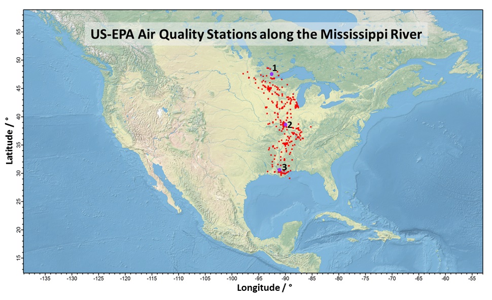
Alongside local and regional sources, the transport of air masses into the Mississippi river region influence air quality. Large-scale differences in air quality can be due to different types of land use, and regional characteristics such as urban centers or rural areas are reflected in the local concentrations of various pollutants, which provide regional evidence of anthropogenic influence. Despite such assumed impacts, so far, no systematic studies of air quality along the Mississippi exist in the scientific literature. However, the extensive network of US-EPA air quality stations along the Mississippi River (Figure 1) are continuously measuring a variety of air quality indicators in this area. This publicly accessible data set contains information on hazardous criteria gases such as ozone, carbon monoxide, sulfur dioxide and nitrogen oxides, on fine and coarse particle concentrations, and on certain toxic particle components at time intervals, in some cases, reaching several decades into the past.
Figure 2: Weekly mass concentration of particulate matter below 2.5 µm particle diameter (PM2.5), measured at the three US-EPA air-quality stations indicated in Figure 1 Graph by Frank Drewnick using data downloaded from www.epa.gov Figure 1: US-EPA air-quality stations in the Mississippi River area. The exemplary data in Figure 2 are from the three marked stations Map data is courtesy of www.naturalearthdata.com
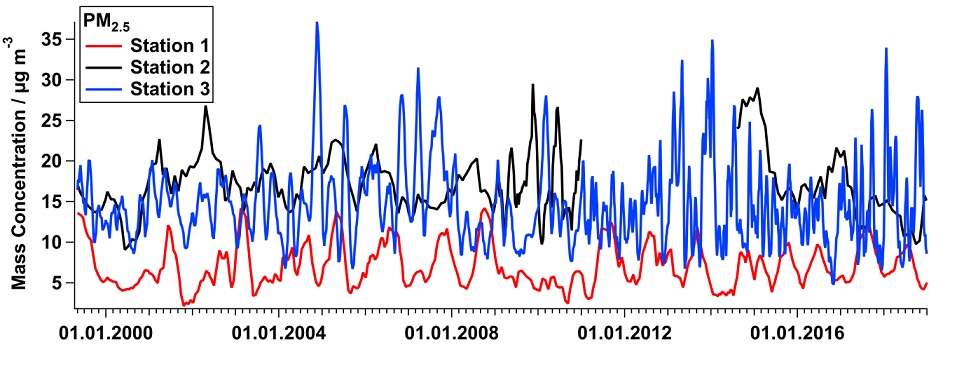
This project will collect highly time-resolved historic pollutant concentration data, taken at regular intervals of one hour, from the US-EPA air quality network stations as far back as possible. These data provide long term temporal evolution of pollutant concentrations for different locations, giving some sense of the relation between the river’s course and pollutant concentration (Figure 2). In further analyses, the spatial distribution of pollutants and regional differences in the observed trends will be investigated, as well as typical daily, weekly or seasonal patterns in different regions or types of environments (urban, rural, industrial). All this information will be used to determine influences and trends in airborne pollutants, as signs of anthropogenic influence, over the last decades in various areas and environments along the Mississippi.