Karlsplatz, Wien Museum, Vienna, Austria

Site Introduction
Karlsplatz is a square in Austria’s capital city, Vienna. Today it is home to the Resselpark, the Karlskirche (a baroque church completed in 1737), the main building of the Technische Universität Wien, and the Wien Museum—adjacent to which is the research site. Historically, the River Wien (a tributary of the Danube) flowed here, but a two-kilometer-long city-center stretch of the river—including the area that is now Karlsplatz—was covered over in the late nineteenth century. An enclosed market hall occupied Karlsplatz from 1921 to 1936. The site, along with much of the city, suffered bombing and destruction during World War II. Groundwork for the Wien Museum began in the 1950s, and it has curated historical and art exhibitions since its opening in 1959. In 2019, it was closed for renovations, which exposed the urban sediments now being studied as an auxiliary stratotype1 for the Anthropocene.
The city sits in the Vienna Basin, a sedimentary basin between the Alps and the Carpathian Mountains, and the area has a long human history, with traces of occupation extending back to the Paleolithic period. A Celtic settlement was established by the River Danube around 500 BCE, and, in the first century CE, became Vindobona, a Roman garrison town of 15,000 inhabitants that would become the seed of the current capital. The city went through various phases of historical importance, being the seat of the Holy Roman Empire (1558–1806), the Habsburg Empire (1806–67), and the Austro-Hungarian Empire (1867–1918). The population peaked at 2 million in the early twentieth century with industrialization, before falling to 1.5 million after World War II. Today, around 1.9 million people live there.


Location of the Section
Unlike the other sites being studied for markers of the Anthropocene, the material from the Karlsplatz site is not a candidate GSSP2 since it does not fulfill all the criteria needed to define the lower boundary of a geological epoch as specified by the International Commission on Stratigraphy. Importantly, because the samples being tested are urban deposits—including rubble from World War II and anthropogenic soils—there is not the continuous record required for a GSSP. Anthropogenic sediments do not contain annual layers, since deposition rates are highly variable, and the layers can get mixed and reworked during different construction phases. Further, because the site will be covered over once the renovations of the Wien Museum are complete, future sampling (another criteria for GSSP candidates) will be hindered. However, the site could be used to define an auxiliary stratotype3 for the Anthropocene, as the stratigraphic markers and technofossils in the urban rubble contain signals that have potential correlations with findings from the candidate GSSP sites.
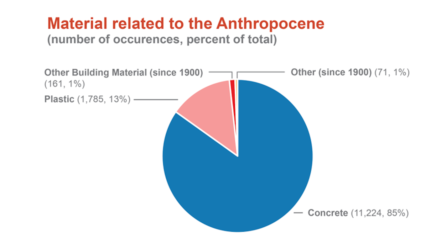
The research at the Karlsplatz site is part of a larger project that looks at more than 60,000 borehole sites (from old wells) and archaeological data across the city. These reveal a variety of anthropogenic materials, including glass, metals, brick, ceramics, and residential waste, with concrete and plastic making up the majority since 1900. However, Karlsplatz is so far the only one of these Vienna sites that has provided radionuclide evidence for a distinct Holocene–Anthropocene stratigraphic boundary layer.


The Sediments and Results
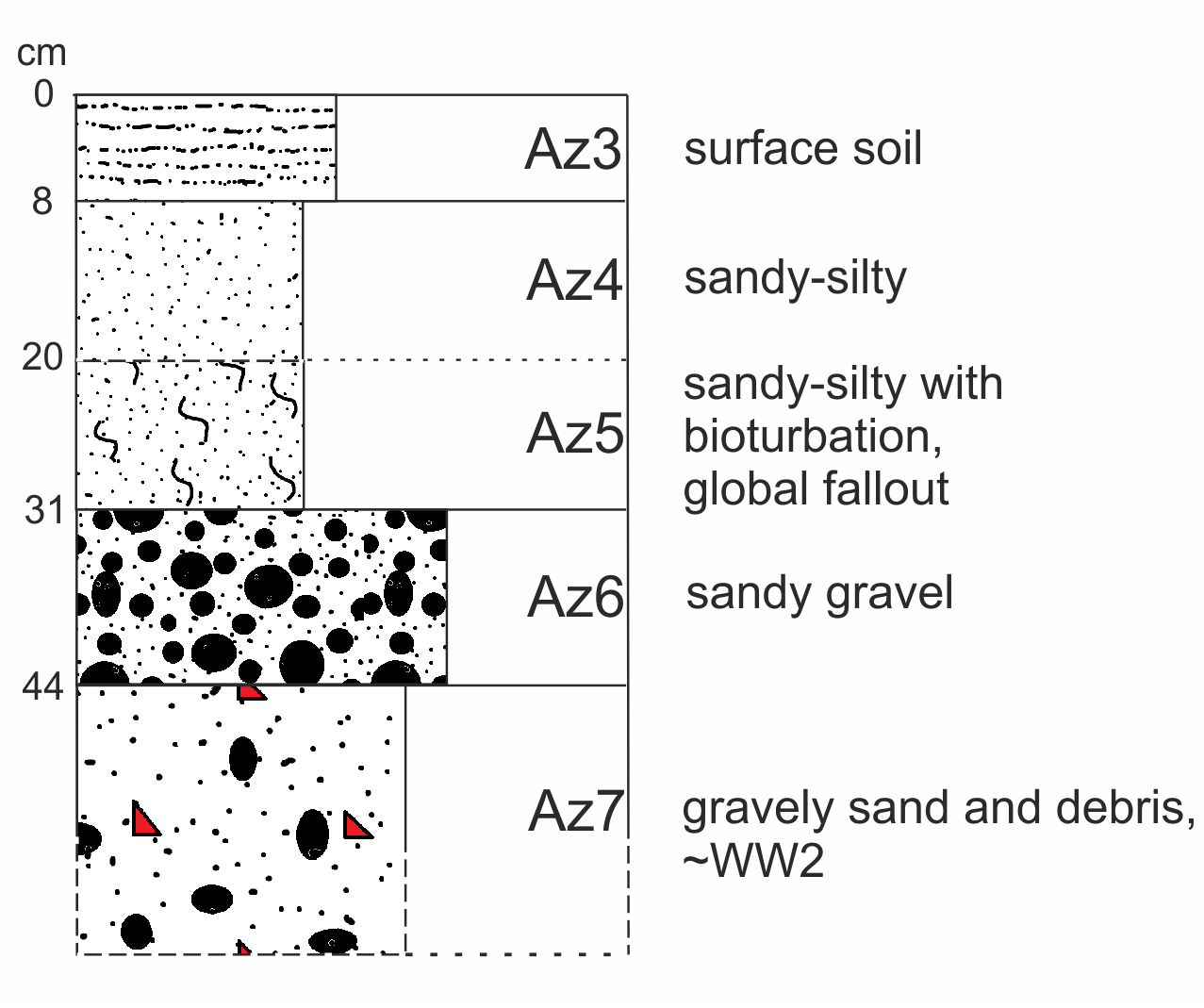
The sediments at the Karlsplatz site are a mixture of rubble, gritty soils, and technofossils,4 including shards of glass and relics of World War II (such as helmets, revolvers, and insignia). Remains, descriptions, and photographs of different historical stages of the site—river bed infill, river pavement, market hall, warzone, museum—allow the various layers of the excavation to be dated with a resolution of five to twenty years, especially within the more recent layers that cover the proposed Holocene–Anthropocene transition. The walls and basement of the market hall (built 1921–22) form the base for the Anthropocene stratigraphic section. The World War II rubble, which fills the remains of these constructions, contains significantly high concentrations of lead, zinc, and copper (from various industrial sources) and some traces of plutonium (which may reflect contamination from the formerly exposed rubble surface or later sediments). The rubble and overlying finer-grained artificial ground and soil build an unconformity5 that is historically dated as post-World War II, representing a few years of ongoing renovations after 1945. In the overlying soil layers (up to 1959, the year of the museum’s opening when the park area was leveled and recultivated), high concentrations of radionuclides appear (including plutonium, uranium, and americium) together with characteristic radionuclide ratios (plutonium-240/plutonium-239) reflecting fallout from atmospheric nuclear bomb testing. The appearance of these markers in coarse urban anthropogenic sediments of big cities demonstrates the globally synchronous appearance of the radionuclides, which makes them exemplary for defining the Anthropocene.

Image by Michael Wagreich © All Rights Reserved
Image by Michael Wagreich © All Rights Reserved


Collection and Analysis
Samples were taken from the Karlsplatz excavation site between October 2019 and January 2020 and classified according to grain size of larger particles and the proportion of other fine-grained, clayey material. The samples were then sieved to separate grains smaller than two millimeters, which were dried and pulverized. Elemental content was measured using X-Ray Fluorescence techniques. This sediment sample was prepared for chemical separation of actinides,6 which were then analyzed by accelerator mass spectrometry (AMS) using the setup at the Vienna Environmental Research Accelerator (Isotope Physics Group). The samples were analyzed for concentrations (atoms per gram) of uranium-233, uranium-236, uranium-238, neptunium-237, plutonium-239, plutonium-240, plutonium-241, and americium-241. Isotope ratios (plutonium-240/plutonium-239, plutonium-241/plutonium-239, and uranium-233/uranium-236) were calculated to trace atomic bomb fallout material from the 1950s and 1960s.


The Research Team
The group formed to propose an interdisciplinary project on Vienna’s urban anthropogenic sediment by the artist Katrin Hornek and geologist Michael Wagreich. Discussions with members of the Anthropocene Working Group, especially Matt Edgeworth and Colin Waters, helped with further formulation of the project. The proposal was granted by the Vienna Science and Technology Fund, and the project started in January 2018. They cooperated with Christine Jawecki and archaeologists Martin Mosser, Constance Litschauer, and Nikolaos Piperakis. PhD students Maria Meszar, a sedimentologist and geochemist, and Kira Lappé, an archaeologist and geographic information system (GIS) specialist, have been with the project since its outset, and were later joined part-time by Veronika Koukal and Mehwish Bibi. Sample processing was severely delayed by COVID-19 pandemic lockdowns. Karin Hain, an isotope physicist, joined the group in 2020 and brought her expertise and isotope analytical skills to the project, together with her master’s student Janis Wolf. Some of the project group will continue investigating the anthropogenic sediments and the historical development of Vienna and the area downstream of the river Danube, a settlement area since Roman times.


Principal investigators (listed alphabetically):
Michael Wagreich, University of Vienna, Principal Investigator, Stratigraphy
Contributing Scientists/Researchers (listed alphabetically):
Karin M. Hain, University of Vienna, Plutonium, radionuclide analysis
Katrin Hornek, University of Applied Arts Vienna, Co-PI, site documentation
Christine Jawecki, Municipal Department 28, Vienna, Vienna core data base
Veronika Koukal, University of Vienna, Trace metal analysis
Kira Lappé, University of Vienna, GIS modelling, archaeology
Constance Litschauer, Wien Museum, Site archaeology
Maria Meszar, University of Vienna, Lithostratigraphy, trace metal analysis
Martin Mosser, Wien Museum, Archaeological stratigraphy
Nikolaos Piperakis, Wien Museum, Site archaeology
Janis Wolf, University of Vienna, Radionuclide analysis
Institutions / Funding bodies (listed alphabetically):
University of Vienna, Austria
Vienna Municipal Department 28 – Road Management and Construction, Austria
WWTF – Vienna Science and Technology Fund, Austria
This article is distributed under the terms of the Creative Commons Attribution-NonCommercial 4.0 License (https://creativecommons.org/licenses/by-nc/4.0/) which permits non-commercial use, reproduction and distribution of the work without further permission provided the original work is attributed as specified on the SAGE and Open Access page (https://us.sagepub.com/en-us/nam/open-access-at-sage).
- Katrin Hornek website
Vienna Anthropocene Network website
Meszar, Maria, Karin Hain, Kira Lappé, Martin Mosser, Katrin Hornek, Veronika Koukal, Constance Litschauer, Nikolaos Piperakis, and Michael Wagreich. 2021. “The Anthropocene bomb-spike in urban strata of Vienna, Austria.” Abstract AGU Fall Meeting (13–17 December 2021), GC55L-05.
Meszar, Maria, Karin Hain, Michael Wagreich, Kira Lappé, Martin Mosser, Katrin Hornek, Veronika Koukal, Constance Litschauer, and Nikolaos Piperakis. 2021. “Tracing the Anthropocene bomb-spike in urban strata of Vienna” EGU General Assembly online (19–30 Apr 2021). https://doi.org/10.5194/egusphere-egu21-11930.